A solo dualsport journey from into north-central British Columbia reveals a lonely, isolated landscape that may not be very lonely for much longer.
Kitwanga Junction is the largest hive of activity I’ve seen since leaving Vancouver, some 1,200 kilometres nearly due south. My KLR is dwarfed by a random collection of massive ore trucks, tractor-trailers, RVs with US state plates, campervans, and trucks all lining up in the August heat at the Petro-Canada. On the back of one truck is a small transmission tower.
 All are pushing their way to the gas pumps, the pressure palpable. There are fewer places to fill up, and those places will continue to diminish.
From here, if I were to continue west, I would be in line with Terrace and Prince Rupert, but if I turn north, crossing the Skeena River, I would be traveling one of the most remote highways in British Columbia, Highway 37. Gityanow, Meziadin, Stewart, Kinaskan, Iskut: small communities await me in isolation on a stretch of road lasting more than 700 kilometres to a junction with the Alaska Highway. That’s where I’m going. I’ve got my tent, and I’m planning to use it.
Before this trip, I had never been north of Williams Lake, having grown up in Victoria and lived in Vancouver most of my life. But as I arrived at this chaotic, hazy service station, I realized the adventure was beginning. Many a bike trip is fuelled by the inevitable approach of 40 years of age, and I have to admit, that it had something to do with this one.
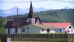
I cross the span of the bridge over the Skeena. The subtle but powerful rush of water beneath me reminds me of two other major salmon rivers I will cross in the days to come, the Nass, and the Stikine. As I weave by the homes and church of the village of Kitwanga, I focus on looking for the signs for Gitanyow, about 15 kilometres north, where some of the most ancient totem poles in British Columbia are located. The sun is baking hot as I ride along a one-lane road a short distance off The 37, pulling into a gravel lot, greeted by a line of poles towering above me and my KLR. The interpretive centre is closed. But I do speak with Lawrence, who introduces himself as a hereditary elder. I told him of my travels along The 37. He says gold mining is “the future” for him.
Lawrence himself is off soon to Dease Lake to stake an interest, pointing on my tank bag map to an area west of The 37. “There’s gold all over the place there,” he tells me. It’s not the first I’ve heard of copper and gold mining near my route.
 Further north I know of a conflict between the Tahltan First Nation and the British Columbia government about the go-ahead for a big mine. I see a “3 Rivers 1 Future” sticker in Kitwanga Junction, reminding me of the inherent dangers of an open-pit mine near salmon rivers.
Back on the road, I’ve taken to saying “groovy baby.” It’s because the grooves in the highway seem to be guiding my KLR’s overinflated tires where they want to take them. I imagine they are created by snowplows in the massive snows that need to be cleared in the depths of winter. It’s a reminder of how inhospitable this remote place will be in just a few months. The sides of the road descend into deep foliage. On my way, I slow to avoid colliding with an RCMP cruiser, which has pulled over to investigate a SUV rolled over into a ditch.
After crossing a single-lane bridge spanning the Nass, I’m a stone’s throw from my first camping destination along the highway, Meziadin Lake. I can’t wait to camp here at this quiet lake, a jumping off point for my voyage tomorrow into the Alaska panhandle. Scoring a peaceful spot next to a brook spilling a trickle of water into the massive lake, I’m struck by how devoid of properties it is. Other than than this campground, it is completely pristine. It’s part of why I’ve come up here, I remember.
 Soon, I have neighbours. Wes and Nancy Taylor pull in next to me in their Hitchhiker II trailer and white Dodge pickup with Colorado plates. Before long Wes is shaking my hand. I learn that when he saw my bike, he had to talk to me. With a collection of motorbikes to his name (his 2008 KLR being his favourite), this retired air force veteran became curious. After all, mine was the only motorbike here in a campground overwhelmingly populated by massive RVs and trailers. Having seen Alaska from tip to toe, the Taylors are on their way southward on the gradual journey home after having completed their bucket list trip of visiting every US state.
There are some things you plan to do for ages. Two of them for me were to see a glacier and venture into Alaska. I did them on the same day. From Meziadin Junction, I veered off the 37 onto 37A (or the Glacier Highway) on to Stewart, British Columbia and its neighbour, Hyder, Alaska. It was a scenic and curvy 65 kilometres. Along the way Bear Glacier emerges on the left about halfway there. It is a gorgeous sight nestled in between two peaks, crashing down into Strohn Lake. Continuing along, the ride has its chilly bits as gusts of cold air bristle off the low-lying ice leftover from the previous winter. Gushing waterfalls topple over cliffs to the right before I arrive in Stewart. As I fuel the Kawasaki I’m told the service station tanks are drying up, any fillup now and they will have nothing left. I would not want to be up here with a tank on reserve!
 Meeting the Taylors and their truck at the Stewart Visitor Centre, we proceed along a five-km stretch of the Glacier Highway separating the town of Stewart, BC from the village of Hyder, Alaska, which lies at the very bottom of the Alaska panhandle. Though there was once a tiny one-man US customs office at the “border,” today you’d hardly know you’ve entered the United States of America except for the odd, half-hearted Stars and Stripes hanging on dilapidated buildings. But you have indeed made a border crossing of sorts, as the asphalt turns to gravel and you riding along the main street of this 1920s mining town.
Decomposing shacks and dark pubs hanging the aforementioned torn and disheveled American flags greet you as you get up on the footpegs to post a watch for the many potholes. After a few turns, the Taylors and I are soon upon “The Bus,” a school bus converted into a seafood eatery by Premier Seafoods. We tuck into a generous helping of halibut and chips, while black bears are chased from the bushes by large local dogs. We chat about our adventures.
Later, I briefly stop at the Hyder General Store and notice a large dumptruck rumble down the gravel road, kicking up loads of dust. Inside I ask Les, the manager, about it and he tells me the streets are about to be paved for the first time. I’ve come to town at an historic moment. A water truck sprays the gravel of the street one last time as I proceed with my passport to Canadian customs (yes, there’s one of those here).
 NEXT DAY AS I SIT IN A SKI LODGE in what feels like the middle of nowhere enjoying some hearty bean and lentil soup and a decent sandwich, I ask the café attendant about rumours of heli-logging up ahead. I’m in a place called Bell II, but it feels like Whistler. Erin tells me it’s true and she doesn’t like the untidy way they stack up the residual logs. Like teepees, she says. Sure enough, another 40 km north I’m thumping right into it. There’s a massive helicopter hovering like a bee from treetop to treetop while large trucks aid in the clearing of logs. This isn’t logging. It’s the creation of power lines into this remote part of the province. Mining projects and communities can’t grow without electricity. Things are changing in the north. There they are, massive cones of ancient trees, on either side of the highway, piled up against one another, like the lairs of forest giants. The scent of fresh-cut spruce and hemlock permeates the air, and fills my HJC.
I arrive at pristine Lake Kinaskan where I make camp in the provincial campground and unpack aluminum panniers while looking forward to a boil-in-the-bag campfood extravaganza courtesy of my pocket campstove.
After supper I loll in the cool lake admiring my tent, the treeline view and the silence in which I feel completely alone, except for some mosquitoes and chipmunks.
Even after a campfire though, I enjoy only a mediocre night’s sleep, followed by a brief breakfast of oatmeal and instant coffee. With that I’m back on the road and there’s only a short distance between here and a bed at the Red Goat Lodge near Iskut. But it seems as though the isolation, the remoteness of the country, and a lack of sleep are affecting me. I’m getting worn-down and edgy. Little things such as the rough and gravel-paved road surfaces I’m now encountering are concerning me, even though the KLR is shod with new knobby Micheline T63s.
 By the time I reach Eddontenajon Lake, I feel quite spent. It’s there I realize I should stop pushing for long distances every day. I need to slow down and appreciate where I am. But is two weeks enough for this trip then? I decide to turn around at the Stikine, the last of the three great rivers I want to see along this route.
AT THE LODGE, I FALL INTO conversation with Mitch Cunningham, who has run this rustic cabin and campground site for 20 years. He says he’ll often provide a breakfast in his large kitchen for workers heading to the hydro development projects, the creation of a power line extension happening nearby. He tells me there are thousands working on them. He supports the creation of Red Chris, a controversial copper and gold mine that promises to create a few hundred jobs for the area, even though critics say the project may well threaten the three great salmon rivers I’ll cross on this trip.
The next day I ride across a metal grid bridge, about a hundred metres long, spanning the Stikine. There have been several bridges like this, which are dangerous for bikers as they lock you in and take you where they want you to go, but this is the longest. I find holding your breath and attacking at speed is the best way to deal with them. There has been significantly less gravel than expected; only a couple of km worth leading north to the Stikine bridge. At the other end of the bridge, I turn the KLR around, pull over, and admire the Stikine River’s current. On the other side, a group of a half dozen adventure kayakers is starting a journey of their own.
 The breeze off the river and the noonday sun are welcome as I enjoy the peace of this place. But riding through this land has also shown me a previously unknown aspect of British Columbia, my home province. It has given me respect for the small communities that deal with being in such a remote place. Although, it would seem, this part of BC may not be isolated for much longer.
By Trevor Hughes, Canadian Biker #289
BACK TO MORE TRAVEL STORIES

Related Stories and Pages:
 Follow The Tramp – Yukon and Alaska
 The Dempster Highway and the Yukon – Northern Essentials
 MOTORCYCLE TRIPS – Canada and the World
 The Over The Hill Gang – Bella Coola Adventure
 Hurley River FSR To Bralorne – A Gold Mining History Tour (BC)
 To KLR or To Not KLR – Touring Choices